
On this page 17 sections
- Closed Seas, Open Seas
- The Zones in Outline
- Fixing the Baseline
- Internal Waters
- The Territorial Sea
- Innocent Passage
- The Contiguous Zone
- Exclusive Economic Zone
- The Continental Shelf
- Shelf and EEZ Compared
- The High Seas
- India's Maritime Statute
- Aban Loyd Chiles Offshore
- The Enrica Lexie Case
- Questions Left Open
- The Zones in Brief
- Quick Clarifications
On 15 February 2012 the Italian tanker Enrica Lexie, with armed Italian marines on board, fired on an Indian fishing boat about 20.5 nautical miles off the Kerala coast. Two fishermen died.
Whether Kerala's police, the Union of India, or Italy could deal with the marines turned on a single fact: which belt of sea the shots were fired in.
The sea off a coast is not one body of law. It is cut into belts measured from the same line, and each belt gives the coastal State a different bundle of powers. This article walks outward from the shore, belt by belt, and then reads India's statute of 1976 and the two Supreme Court cases that show the belts at work.
Closed Seas, Open Seas
The law of the sea began as a quarrel between two ideas. The theory of closed seas (mare clausum) let powers such as Spain, Portugal and England claim huge stretches of ocean. Grotius answered with Mare Liberum in 1609: the oceans were open to all. By the eighteenth century the open-sea view was winning, but a belt of water next to the coast was still treated as part of the State.
Much of later history is an argument about how wide that belt should be.
The Geneva conference of 1958 adopted four conventions but left the width of the territorial sea undecided.
The third conference ended on 30 April 1982 at Montego Bay, Jamaica, with the Convention on the Law of the Sea: 320 articles, nine annexes, adopted as a package deal without reservations.
It came into force on 16 November 1994. India signed it in 1982 and ratified it on 29 June 1995.
The Zones in Outline
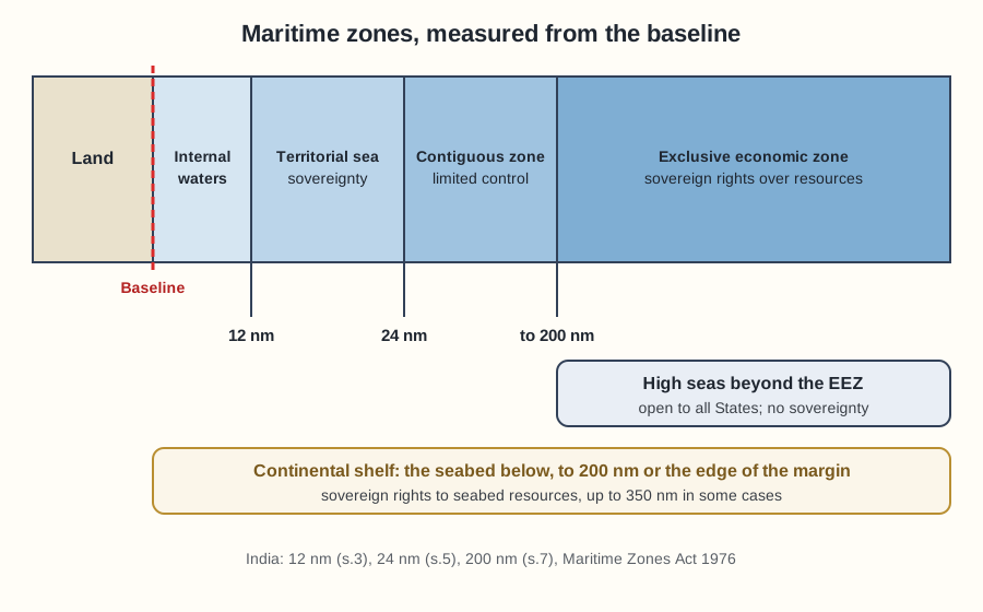
The Convention recognises six areas, which fall into three groups:
- Within national jurisdiction: internal waters, the territorial sea and archipelagic waters, treated as part of national territory.
- Beyond territory, with functional powers: the contiguous zone and the exclusive economic zone, where the coastal State may act only for stated purposes.
- Beyond every State: the high seas.
The continental shelf sits across the groups. It begins inside national waters and runs beyond them. Every belt is measured outward from one reference line, the baseline.
Fixing the Baseline
Article 5 makes the normal baseline the low-water line along the coast, as marked on large-scale charts officially recognised by the coastal State. The rule breaks down on a ragged coast. In the Anglo-Norwegian Fisheries case (1951) Norway measured its northern waters from straight lines joining the outermost points of the skjaergaard, the fringe of islands and rocks along its coast.
The International Court upheld the method, relying on geography, Norway's consistent use since 1869 without objection, and the dependence of the inhabitants on fishing. It allowed regard to
‘certain economic interests peculiar to a region, the reality and importance of which are evidenced by long usage’
Article 7 now carries the rule. Straight baselines are for a deeply indented coast or a fringe of islands in its immediate vicinity, and the lines must not depart appreciably from the general direction of the coast. Because they push a State's sea border outward, they are contested often. In Qatar v. Bahrain (2001) the Court stressed that
the method of straight baselines, which is an exception to the normal rules for the determination of baselines, may only be applied if a number of conditions are met.
Islands and Rocks
An island, defined in Article 121(1) as a naturally formed area of land surrounded by water and above water at high tide, generates every belt: territorial sea, contiguous zone, economic zone and continental shelf. Article 121(3) cuts the entitlement of the smallest features:
‘rocks which cannot sustain human habitation or economic life of their own shall have no exclusive economic zone or continental shelf’
A rock keeps its territorial sea. Artificial islands generate only a 500-metre safety zone under Article 60(5).
An archipelagic State, such as one made up wholly of islands, may join the outermost points of its outermost islands by straight lines under Article 47, within fixed ratios of water to land and limits on line length; other States keep innocent passage and archipelagic sea-lanes passage through the enclosed waters.
Internal Waters
Article 8 puts the inner boundary in a line:
waters on the landward side of the baseline of the territorial sea form part of the internal waters of the State.
Ports, bays, river mouths, canals, rivers and lakes fall here. They are part of the State's territory and the coastal State has complete sovereignty over them. Foreign ships have no right of innocent passage.
The one clear right of access to a port is that of a ship in distress with lives at risk; otherwise the State sets the conditions of entry.
A foreign merchant ship in port comes under the civil and criminal jurisdiction of the coastal State, though purely disciplinary matters of the crew are often left to the flag State by courtesy.
A warship is different: as an arm of its flag State, it cannot be subjected to local jurisdiction without the captain's or the flag State's consent.
One exception to the rule of no passage remains. If straight baselines enclose as internal waters an area that was earlier territorial sea or high seas, a right of innocent passage continues there.
The Territorial Sea
Beyond the baseline lies the territorial sea. Article 2 states the principle:
The sovereignty of a coastal State extends, beyond its land territory and internal waters and, in the case of an archipelagic State, its archipelagic waters, to an adjacent belt of sea, described as the territorial sea.
The sovereignty reaches the air space above and the bed and subsoil below, subject to the Convention, and above all to the right of innocent passage. Because the belt follows from sovereignty over the land, it exists as of right and need not be claimed. A cession of land carries the adjoining belt with it.
The difference from internal waters is the heart of the matter. Both are sovereign territory. But internal waters lie landward of the baseline and are closed to passage, while the territorial sea lies seaward of it and must stay open to the innocent passage of ships of every State.
How Wide Is It
The first answer was the range of a cannon shot, fixed at three nautical miles and backed by the United Kingdom and the United States. When guns outranged it, the rule lost its reason.
The Hague Conference of 1930 failed, Geneva in 1958 left the question open, and in 1960 a proposal for a six-mile sea plus a six-mile fishing zone fell short by a single vote. Article 3 of the 1982 Convention settled it:
Every State has the right to establish the breadth of its territorial sea up to a limit not exceeding 12 nautical miles, measured from baselines determined in accordance with this Convention.
Article 4 fixes the outer limit as the line each point of which is twelve nautical miles from the nearest point of the baseline. One nautical mile is 1.852 kilometres. Twelve miles is a ceiling, not a duty: a State may claim less.
A claim beyond twelve miles binds only States that recognise it. India fixed its limit at twelve miles in section 3 of its 1976 Act.
Innocent Passage
Article 17 gives ships of all States the right of innocent passage through the territorial sea. Passage must be continuous and expeditious (Article 18).
It is innocent so long as it is not prejudicial to the peace, good order or security of the coastal State, and Article 19 lists twelve activities that make it non-innocent, including weapons exercises, spying, fishing, research and serious pollution. Submarines must navigate on the surface and show their flag (Article 20).
The coastal State may make laws on navigation, conservation, pollution and customs, fiscal, immigration and sanitary matters (Article 21). It may not hamper innocent passage, discriminate between ships, or charge merely for passage (Articles 24 and 26). For a crime on a passing ship, Article 27 allows arrest only where its consequences extend to the coastal State, it disturbs the peace, the master or flag State asks for help, or it involves drug trafficking.
Warships
The text does not say in so many words that warships have a right of innocent passage, and States disagree on whether prior notice or permission is needed. The leading case is Corfu Channel (1949). British warships passing through Albanian waters struck mines in October 1946, with heavy loss of life. The International Court held Albania responsible for failing to warn of a minefield it must have known about, and said that
states in time of peace have a right to send their warships through straits used for international navigation between two parts of the high seas without the previous authorisation of a coastal state, provided that the passage is innocent.
The fuller treatment is in a separate article on innocent passage and the Corfu Channel case. The 1982 Convention also added transit passage for straits used for international navigation, a freedom of navigation and overflight for continuous and expeditious transit that bordering States may not suspend.
The Contiguous Zone
A narrow territorial sea invites a simple evasion: a smuggler waits just outside it. The contiguous zone answers that problem. The 1958 Convention allowed one of up to twelve miles from the baseline, which left nothing once States claimed a twelve-mile territorial sea. Article 33 of the 1982 Convention revived it:
In a zone contiguous to its territorial sea, described as the contiguous zone, the coastal State may exercise the control necessary to
prevent infringement of its customs, fiscal, immigration or sanitary laws within its territory or territorial sea, and punish infringement of those laws committed there. Paragraph 2 sets the limit:
The contiguous zone may not extend beyond 24 nautical miles from the baselines from which the breadth of the territorial sea is measured.
With a twelve-mile territorial sea, the zone is the twelve miles beyond it. The four heads are a closed list, and the coastal State has no sovereignty there. Unlike the territorial sea, the zone must be claimed. The International Law Commission had refused to add security to the list:
The Commission did not recognise special security rights in the contiguous zone. It considered that the extreme vagueness of the term ‘security’ would open the way for abuses and that granting of such rights was not necessary.
India took a firm position on the zone. At the third conference many delegations thought a 200-mile economic zone made it superfluous. India insisted that it stay, because it was not certain that the economic zone would give the coastal State power over customs, fiscal, immigration and sanitary laws, and many delegations supported it. India's own statute goes further than Article 33, as the section on the 1976 Act below shows.
Exclusive Economic Zone
The economic zone is the newest belt and the only one created by the 1982 Convention. Its roots lie in fisheries claims, such as Iceland's extension of its fisheries zone to fifty miles in 1972.
The zone itself was proposed by Kenya in 1972, with India among its chief supporters, and the International Court has since accepted it as part of customary international law. Article 57 fixes the breadth:
The exclusive economic zone shall not extend beyond 200 nautical miles from the baselines from which the breadth of the territorial sea is measured.
Article 56(1) gives the coastal State
sovereign rights for the purposes of exploring and exploiting, conserving and managing the natural resources, whether living or non-living, of the waters superjacent to the sea-bed and of the sea-bed and its subsoil
together with jurisdiction over artificial islands, marine scientific research, and the protection and preservation of the marine environment.
Article 73 allows boarding, inspection and arrest to enforce its laws. In return it must conserve living resources and share any surplus catch. One commentary puts the position this way:
the coastal State is not the owner, but rather the “guardian of the natural resources within its EEZ.”
Other States keep the freedoms of navigation, overflight and laying cables and pipelines (Article 58). The zone does not come with the land: a State must claim it. Critics point out that a 200-mile line has no scientific basis and has shrunk the high seas, at a cost to landlocked States.
The Continental Shelf
The shelf is older. President Truman's proclamation of 1945 claimed the resources of the shelf off the United States. The International Court gave the doctrine its foundation in the North Sea Continental Shelf cases (1969): the coastal State's rights over the shelf, a natural prolongation of its land territory under the sea,
exist ipso facto and ab initio, by virtue of its sovereignty over the land
so no proclamation is needed. Article 76 defines the shelf as the seabed and subsoil extending through that natural prolongation to the outer edge of the continental margin, or to 200 nautical miles where the margin does not reach so far. Where it does, the limit may run to 350 miles, after a claim to the Commission on the Limits of the Continental Shelf.
The coastal State has sovereign rights to explore the shelf and exploit its resources: minerals and sedentary species such as shellfish. They are exclusive, so no one else may exploit the shelf without its consent (Article 77), but they do not affect the status of the waters above (Article 78).
Between neighbours, Article 83 calls for delimitation by agreement to achieve an equitable solution. The North Sea cases rejected equidistance as a binding rule, and in 2014 the Bangladesh/India arbitration treated the concavity of the coast as a relevant circumstance. The full treatment is in a separate article on the continental shelf under UNCLOS.
Shelf and EEZ Compared
Inside 200 miles the two regimes overlap, so the real differences lie in their origin, extent and the resources they cover. The 2023 paper asked for exactly this contrast.
| Point | Continental shelf | Exclusive economic zone |
|---|---|---|
| Source | Older rule; rights exist from the start (North Sea cases) | Created by the 1982 Convention |
| Claim | Needs no proclamation | Must be claimed |
| Extent | Margin or 200 miles; up to 350 miles in some cases | Up to 200 miles |
| Resources | Seabed and subsoil: minerals and sedentary species | Water column as well: fish, and energy from water, currents and winds |
| Rights | Exploration and exploitation | Also conservation and management |
| Landlocked States | No provision | Rights to share surplus, Articles 69 to 72 |
The High Seas
The high seas are what is left beyond the economic zone. Article 89 states the rule:
No State may validly purport to subject any part of the high seas to its sovereignty.
Article 87 lists the freedoms of all States: navigation, overflight, laying cables and pipelines, fishing and scientific research, each subject to due regard for others. Order comes from the flag State. In the Lotus case (1927) the Permanent Court said that
vessels on the high seas are subject to no authority except that of the State whose flag they fly.
Article 92 embodies the rule, and Article 97 confines penal proceedings for a collision or other incident of navigation to the flag State or the State of the accused's nationality.
Hot Pursuit
A coastal State need not let an offender escape by crossing an invisible line. Article 111 allows it to pursue a foreign ship onto the high seas, if pursuit begins while the ship is within its waters or zones, a signal to stop has been given, the chase is continuous, and only warships or authorised government vessels take part.
Pursuit ends when the ship enters another State's territorial sea. In the I'm Alone case (1935) a United States coast guard vessel chased a Canadian rum-runner more than 200 miles and sank it; the tribunal held this was not lawful hot pursuit and ordered compensation.
India's Maritime Statute
The Constitution deals with the sea in Article 297. Clause (1) reads:
All lands, minerals and other things of value underlying the ocean within the territorial waters, or the continental shelf, or the exclusive economic zone, of India shall vest in the Union and be held for the purposes of the Union.
Clause (3) leaves the limits of the zones to Parliament. That law is the Territorial Waters, Continental Shelf, Exclusive Economic Zone and Other Maritime Zones Act, 1976. Before it, the limits rested on Presidential proclamations: three nautical miles, raised to six in 1952 and to twelve in 1967.
Section 3(2) fixes the territorial waters:
The limit of the territorial waters is the line every point of which is at a distance of twelve nautical miles from the nearest point of the appropriate baseline.
- Section 4, passage: foreign ships other than warships enjoy innocent passage; warships, including submarines, must give prior notice to the Central Government.
- Section 5, contiguous zone: up to twenty-four nautical miles. The Act adds the security of India to the matters on which the Government may act, and lets it extend enactments on security, immigration, sanitation, customs and fiscal matters to the zone.
- Section 6, continental shelf: India has, and always had, full and exclusive sovereign rights over it.
- Section 7, economic zone: up to 200 nautical miles, with sovereign rights over natural resources; no one may explore or exploit it without a licence.
Two features set the Act apart from the Convention. India claims security powers in the contiguous zone, which Article 33 does not list. And the Government can extend any Indian law to the shelf and economic zone by notification. Section 7(7) then creates a legal fiction:
any enactment so extended shall have effect as if the exclusive economic zone or the part thereof to which it has been extended is a part of the territory of India.
Aban Loyd Chiles Offshore
The first case to put the Act to work was a customs dispute, Aban Loyd Chiles Offshore Ltd. v. Union of India (2008). Companies drilling for oil and gas beyond twelve miles claimed that their rigs were foreign-going vessels, so that stores taken to them were free of customs duty.
Notifications under sections 6 and 7 had extended the Customs Act to designated areas of the shelf and economic zone. The Supreme Court dismissed the appeals. It held that India's rights in those zones
cannot be equated to extending the sovereignty of India over the continental shelf and exclusive economic zone as in the case of territorial waters.
Yet the fiction in sections 6(6) and 7(7) treats the zones as part of India for any law extended there, so stores taken to the rigs went to a deemed part of India. The Court described the economic zone as
a concept of restricted sovereignty linked to the resources sense sans the incidents of territoriality.
The Enrica Lexie Case
The Italian ship Enrica Lexie carried a military protection detachment against pirates. About 20.5 nautical miles off Kerala it met the fishing boat St. Antony, which the marines allegedly mistook for a pirate vessel. Shots killed two fishermen. The ship was asked to return to Cochin, an FIR for murder was registered, and the two marines were arrested by Kerala police.
Italy argued that Kerala had no jurisdiction beyond its territorial waters, that Italy as flag State had the first right to try the marines under Articles 92 and 97, and that the marines had immunity. India relied on a notification of 1981 under section 7(7) extending the Indian Penal Code and the Code of Criminal Procedure to the economic zone.
The Holdings
On 18 January 2013 the Supreme Court held for the Union and against Kerala. Altamas Kabir CJI placed the incident in the contiguous zone, beyond the twelve-mile territorial waters. The extension of the penal laws allowed the Union to investigate and prosecute, but not the State police, whose reach ends at the territorial waters. He said India
can exercise only sovereign rights within the Exclusive Economic Zone for certain purposes.
He rejected Article 97, reading an incident of navigation as an accident such as a collision:
An incident of navigation as intended in the aforesaid Article, cannot, in my view, involve a criminal act in whatever circumstances.
Chelameswar J., concurring, held that applying Indian law to the zones needs a notification, after which the law operates as if the zone were Indian territory. He questioned the language of Aban Loyd, saying that
sovereignty is not “given”, but it is only asserted.
How It Ended
The dispute then moved to the Convention's own machinery. An arbitral tribunal under Annex VII gave its award on 21 May 2020. Italy agreed to pursue its own criminal investigation and to pay compensation of Rs 10 crore. In June 2021 the Supreme Court directed that Rs 4 crore go to the dependants of each fisherman, and closed the matter, holding that
this is a fit case to close all the proceedings in India including criminal proceedings in exercise of powers under Article 142 of the Constitution of India.
Questions Left Open
The status of the contiguous zone remains unclear in Indian law. Kabir CJI spoke of India exercising rights of sovereignty up to 24 miles, while Aban Loyd denied sovereignty beyond the territorial waters, and the Act adds security powers that the Commission had refused to recognise.
The reach of the section 7(7) fiction is also unsettled: how far a coastal State's criminal law may follow its resource rights into a zone where, under Article 58, other States keep their freedoms of navigation.
Beyond India, the line between rocks and islands still decides whether a speck of land carries a 200-mile zone, and States still disagree on whether warships need notice before passing through the territorial sea.
The Zones in Brief
| Zone | Outer limit from baseline | Coastal State's powers |
|---|---|---|
| Internal waters | Landward of the baseline | Full sovereignty; no right of innocent passage |
| Territorial sea | 12 nautical miles | Sovereignty, subject to innocent passage |
| Contiguous zone | 24 nautical miles | Control over customs, fiscal, immigration and sanitary laws (India adds security) |
| Exclusive economic zone | 200 nautical miles | Sovereign rights over resources; limited jurisdiction |
| Continental shelf | Margin or 200 miles; up to 350 in some cases | Sovereign rights over seabed resources |
| High seas | Beyond the economic zone | None; freedom for all States, subject to flag State jurisdiction |
Quick Clarifications
Q: Does the territorial sea have to be claimed?
No. It follows from sovereignty over the land and exists as of right. The contiguous zone and the exclusive economic zone must be claimed, while the continental shelf needs no claim.
Q: Where did India fix the limits of its zones?
In the Territorial Waters, Continental Shelf, Exclusive Economic Zone and Other Maritime Zones Act, 1976: twelve miles for territorial waters (section 3), twenty-four for the contiguous zone (section 5) and 200 for the economic zone (section 7). The shelf is defined in section 6.
Q: Is Article 97 a bar to prosecution by a coastal State?
It covers collisions and other incidents of navigation on the high seas. In the Italian marines case the Supreme Court held that a deliberate firing is not an incident of navigation.
Sources: Constitution of India, Articles 297 and 142; Territorial Waters, Continental Shelf, Exclusive Economic Zone and Other Maritime Zones Act, 1976, as set out in the judgments; text of the 1982 United Nations Convention on the Law of the Sea, as set out in the judgments; Republic of Italy v. Union of India (judgment of 18 January 2013); Massimilano Latorre v. Union of India (2021); Aban Loyd Chiles Offshore Ltd. v. Union of India (2008); commentaries on the Law of the Sea, including the treaty texts and cases as set out there.